Use Google Maps Traffic Screenshots for Urban Planning & Civil Eng.
The use and adoption of Google Maps are limitless. Capture and analyze traffic patterns from Google Maps with automated screenshots at regular intervals.
Google Maps traffic data proves to be very efficient in helping us go from point A to point B and several more ways. There are whole industries built around the application of Google Maps and traffic sensors, such as food delivering apps, two & four-wheeler hiring apps, and courier/parcel delivering freight partners, to name a few.
What makes Google Maps traffic flows monitoring valuable and relevant?
With the help of the Google traffic layer, we can:
- Explore not only our neighborhood but also any place of our choice;
- Monitor the road live traffic condition before stepping out;
- Identify congested routes and roads with light traffic from time to time with different color codes;
- Monitor places or roads expecting higher traffic at certain times;
- Decide on alternate routes than usual to avoid traffic and commute faster;
- Find more information about any place of interest like parks, café, shops, etc.;
- Get real-time live traffic jam updates;
- Know about public transportations available;
- Identify residential, water mass, forest, and commercial areas.
The information above is essential for such working bodies for effective planning and strategizing with traffic data analysis. The GIS information collected and made available through Google Maps is phenomenal for this purpose.
Geographic Information System
GIS (Geographic Information System) collects and manages all types of descriptive information in the context of geographic data and later connects all these to a map. GIS helps its users monitor and analyze such data to find relations between different entities within the dataset, understand trends and changes, and perform forecasting for efficient management and improved decision making.
Who needs such Google Maps traffic flows data analysis?
The use and adoption of Google Maps don’t stop with the above. Several real-life use cases should take advantage of traffic data analysis.
Critical work like city planning, urban planning, construction planning, and infrastructure planning can also benefit from apps like Google Maps. In addition, civil engineering bodies, real estate planning authorities, and other governmental agencies can analyze historical traffic patterns with the help of Google Maps.
Recording and archiving snapshots of Google Maps traffic history for the area under consideration - based on your frequency and granularity, i.e., hourly or daily, zoom level, etc. - can prove beneficial for performing traffic predictions and data analysis (more on this later).
So, if you’re a part of any of these departments, keep reading to know how you could benefit from a tool like Google Maps.
How to analyze Google Maps data: What to look for?
While you start referring to Google Maps traffic flows for your work, there are multiple things you that could start monitoring for your designated area/locality, such as:
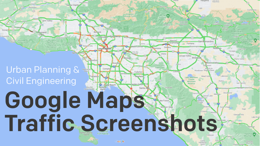
- Analyzing the traffic line colors - Blue for normal to less traffic, amber for moderate traffic, and red for heavy traffic patterns indicating road closures, mishaps, work hour rush time, etc. The color-coding in traffic lines should give you a brief idea of how traffic behaves at different times. For example, if you’re in the city planning or civil construction department, you would probably avoid choosing an always-heavy traffic locality to build a new hospital.
- Time of traffic conditions change - As you keep monitoring the roads and nearby areas for traffic influx, you could also note when things turn back to normal or vice-versa. That way, city planners or real-estate authorities can better decide the location of their next project based on traffic levels, and civil architects can propose where and how to increase road capacity.
- Major events causing traffic congestion - You can also monitor if the traffic conditions are changing because of some significant events in your city, such as a political gatherings, concerts, festivals, and more. You can note if it is a recurring event or a one-time event and how it impacted the roads. That will also help you find ways to manage such recurring or seasonal events in a better way to reduce any bad impact on the roads and commuters.
- Monitoring for anomalies - You can find out if there is anything wrong going on in the area/roads, causing lengthy traffic jams. You can find roadblocks on the route and determine the frequency of such incidents. Suppose you’re able to analyze these details. In that case, it will help you better understand and plan for an alternative route, improvements required in the actual routes, evaluate traffic lights, and figure out ways to manage traffic during such incidents.
Now the question arises about how to start monitoring all these aspects for better decision-making since performing all the above steps manually might seem like a lot.
Google Maps Timelapse
Below is a timelapse video made from Google Maps screenshot image files captured with Stillio from Los Angeles on Google Maps. The screenshots were captured in 5-minute intervals for 24 hours on Nov 4 and 5, 2021. The video shows three different zoom levels merged in one video.
How to get historical traffic data from Google Maps: How to capture and archive GIS traffic data
All you need is access to Google Maps and a Stillio account!
Stillio is a website screenshot service that helps you capture Google Maps data and archive it automatically to be retrieved in the future whenever you need it, for example, for Google Maps traffic analysis.
Here is what you need to do to make Stillio do all the heavy lifting for you.
- Plot Location: Decide on the location or area you’re interested in and plot it on your Google Maps.
- Zoom Level: Google Maps provides multiple zoom levels, from a very granular level of view to a bird-eye view. Once you fix your zoom level, Google Maps applies that setting on their URL deep link.
- Deeplink: Add the complete URL to your Stillio app account and save it. So now, Stillio knows which URL needs to be monitored.
- Capture frequency: Within your capture settings, you can decide how frequently it should take a Google map screenshot of that location and archive it with all relevant information. Stillio allows you to automate the capture frequency like once a day, once an hour, weekly, or even up to every 5 minutes. Once you have Stillio set up, you can forget about taking manual notes by sitting in front of Google Maps for the whole day and focusing on other more important works. Screenshots will be the best way to record such information. They will be able to record different data points mentioned on the above pointers, which will save your time. Also, Stillio automatically archives the screenshots for you. You don’t need to find the sequence of the Google Maps images being captured.
- 24/7 time slots: You could also configure Stillio to capture a snapshot from Google Maps any time, even via pre-defined timeslots such as during weekends, morning, or afternoon rush hours, etc. It can cater to many conditions that might apply to capturing Google Maps data as per your project. And the archive Stillio builds on your behalf will also stay accessible for any future correspondence and reference.
Capture traffic data with Stillio
This is how a once cool invention is now leveraged as a mammoth help to all users involved in civil engineering, city planning, and real estate developing departments to analyze Google Maps for road conditions and traffic information. A picture is worth a thousand words. The good news is that you don’t need to kill time noting every such utterance in your record, as Stillio is here to rescue and capture Google Maps screenshot images for you.